


Sverige Topo Kartan

Opis aplikacije Sverige Topo Kartan
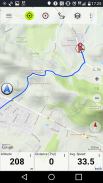
ГПС апликација за навигацију за унутрашњу и спољашњу употребу која се лако користи уз приступ најбољим топографским мапама и сателитским сликама.
++ ПРО функције су потребне за употребу ван мреже! ++
Трансформујте Андроид паметни телефон / таблет у спољни ГПС за путовање у слабо насељеним местима БЕЗ ПОТРЕБЕ ЋЕЛИКА. Ова апликација вам пружа сличне опције мапирања на које сте навикли са ГПС телефонима компаније Гармин или Магеллан.
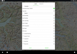
Укључује БЕСПЛАТНО складиштење мапа:
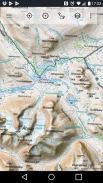
• Топографска карта 1: 50 000 за Скандинавију (Данска, Норвешка, Шведска и Финска) са планинским засјењењем. Мапа терена Лантматериет + Планина планине
• Топовебб: Лантматериет Топографска карта Шведске
• ОпенСтреетМапс: Ове препуне мапе су врло користан додатак другим слојевима мапа и садрже мноштво јединствених функција
• ОпенЦицлеМапс: Ове мапе су савршене за планирање вожње бицикла (само ПРО корисници)
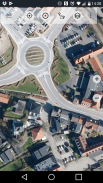
• ЕСРИ топографија
• ЕСРИ фотографије из ваздуха
• ЕСРИ мапа пута
• Гоогле мапа пута (само путем интернета)
• Гоогле сателитске слике (само на мрежи)
• Гоогле карта терена (само путем интернета)
• Бинг мапа пута (само путем интернета)
• Снимање сателитских слика (само на мрежи)
• Земљу ноћу
• Прекривање засјењења стијенама
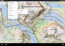
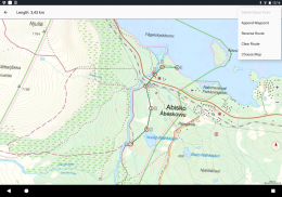
Главне функције за навигацију на отвореном:
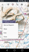
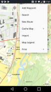
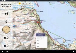
• Креирајте и уредите путне тачке
• Идите на навигацију путне тачке
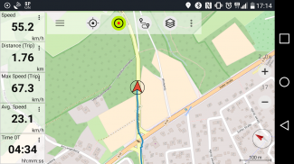
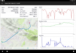
• Снимање записа (са профилом брзине, надморске висине и тачности)
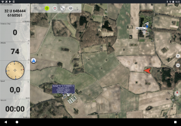
• Трипмастер са пољима за мераче удаљености, просечном брзином, лежајем, висином итд.)
• Извоз ГПКС / КМЛ / КМЗ
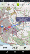
• Претрага (имена места, тачке интереса, путеви)
• Прилагодљива поља података у мапи Мап Мап и Трипмастер (нпр. Брзина, удаљеност, компас ...)
• Дељење тачака, стаза или рута (путем е-поште, Вхатсапп-а, Дропбок-а, Фацебоока ...)
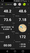
• Прикажи координате у Лат / Лон, УТМ или МГРС / УСНГ (Референтни систем војне мреже / Национална мрежа САД-а)
• Снимите и делите записе са статистикама и профилима надморске висине
• Ротирање мапе (стаза и запис)
• Добијте висину и удаљеност дугим кликом на карту
• Праћење репродукције
• Додајте прилагођене сервере мапа
• И још много тога ...
Доступно за ПРО: (Про функције су доступне за куповину у апликацији)
• Ван мреже - није потребно покривање мобилних уређаја. Без роаминг трошкова!
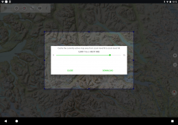
• Једноставно и брзо масовно преузимање мапа за ОФФЛИНЕ УСЕ (не односи се на Гоогле и Бинг мапе)
• Креирајте и измените руте
• Навигација на рути (навигација од тачке до тачке)
• Увоз / извоз ГПКС / КМЛ / КМЗ
• Неограничено са путним тачкама и стазама
• Додајте друге сервере мапа
• Нема огласа
Употреба ван мреже:
Сва приказана поља са мапама чувају се у кешу. Да бисте кеширали велике површине, морате да купите Про функције.
Ову навигацијску апликацију користите за активности на отвореном, као што су планинарење, бициклизам, кампирање, пењање, јахање, скијање, вожња кајаком, лов, оффроад 4ВД туре или спашавање на мору (САР).
Додајте прилагођене тачке пута у дужини / ширини, УТМ или МГРС / УСНГ формату с датумима ВГС84.
Увоз / извоз / дељење ГПС путних тачака / стаза / рута у ГПКС или КМЛ / КМЗ формату Гоогле Еартх.
Претходно учитајте БЕСПЛАТНЕ податке карата за подручја која немају покривеност мобилним уређајима (Про функција).
Коментари и захтеви шаљу се на Сведенмапс@атлогис.цом
Погледајте и остале наше апликације за навигацију на отвореном:
хттпс://плаи.гоогле.цом/сторе/сеарцх?к=атлогис
++ Не пратимо корисничку активност нити прикупљамо корисничке податке! ++

Sverige Topo Kartan - Informacije o APK datoteci
Verzija APK datoteke: 7.8.0Paket: com.atlogis.swedenPoslednja verzija aplikacije Sverige Topo Kartan
Druge verzije


Aplikacije u istoj kategoriji

Možda će vam se takođe dopasti i...


